Thursday, June 30, 2011

Cloudburst

 
I rode out along the Colorado River before sunup under a dark and rumbling sky.  Kane Creek Road winds peacefully along the slow-moving river, and I figured I’d see more on the way back.  I locked the bike to a post where the sign reads, “The Moab Rim Route follows a sandstone ledge to the rim above Moab, gaining 1,000 feet in about a mile.  Rated 4+ by the Red Rock Four-Wheelers Jeep Club.  Standard jeeps cannot make it.”  I figured I could go where standard jeeps can’t. 


Clouds moved fast overhead as I climbed the sandstone bench that angles steeply up from the river.  White marks painted on the rock guide jeep drivers, which I was happy not to be.  I have never seen a road so steep and don’t see how any jeep, no matter how modified, could make it.   See how the rocks have been scratched and chipped by jeep parts as they climbed upward in the right picture.  Just follow the white marks, folks, and obey all traffic laws.


Soon the cloud that had been muttering from beyond the ridge came into full black view and fired a warning shot.  I looked for cover and found it under a rock overhang with about three feet of head clearance where I could cower some four feet into the wall.  There I stayed dry while rain began, not slowly, but in a deafening blast of huge drops and hail.  I snapped these pictures of the splashing drops from inside my lair.


It was over in fifteen minutes, and I went out into a new world, where dry had been transformed into wet.  I heard a roar as of a nearby waterfall.  I looked up at what had been a dry sandstone cliff, now plashing with a streaming waterfall pouring over its top.  And beside me, where dry rock had been, a creek flowed.  The sound of it was not loud like the storm, but peaceful as a mountain meadow.


I watched the waterfall and the creek for some time, perhaps fifteen minutes, until they stopped flowing.  Here is the place where the waterfall was.


As the storm moved away, sun played on its clouds, painting their edges with silver and their undersides in burnt ochre.  I felt like I had been transported to another world and returned safely to earth.


As I walked back down the jeep trail, the Colorado River brightened into its midday normality.  The storm had dispersed into a few thin clouds, and mud covered some of the smooth rocks, making the descent difficult even for a non-jeep.

Wednesday, June 29, 2011

A Strange Day


Tiny arches, this view about three feet high


I had the usual anticipation this morning—another hike, another strange canyon, new distorted rocks.  I opened the door and immediately felt warmth, unusual for pre-sunrise, and wind from the south, also unusual to one who lives here and knows nature’s patterns.  Looking up, I found no stars, and that shook me.  I think that one of the reasons I get away with what most people call danger is that I can change in a New York minute, turn on a penny’s worth of evidence, a hunch, intuition.

I had told him I wanted to see a flash flood before I leave Utah, and he said it gets scary around here in a thunderstorm.  Only nine inches of rain falls on an average year, and most of it comes in violent storms.

Any anasazi would have taken this morning’s signs as ominous, any cowboy who came to these mesas, even a uranium prospector bent on radioactive gold, and even me after three weeks. A sense comes with the desert, a feeling.

So I didn’t go the canyon, didn’t see the golden sunrise, but went instead to a café, ordered coffee.  I sat outside, which normally would be cold at this hour.  My sitting was humidly and unpleasantly warm, but interesting because I watched a thunderstorm come in from the south, blacken the sunrise, and move out of here, all within thirty minutes.  It dropped no rain. 

The wind stopped, the day turned hotter than any since my arrival.  It felt wrong to go out in the sun for long, but not wrong to make the short drive into The Arches for a walk down Park Avenue, which they named for the rock “buildings” that line it.


Here is my castle with adjoining tower from which I survey my kingdom and the works that I have done. 


This rock was set squarely on its pedestal many years ago, but I moved it to the side just enough to worry everyone.


A Chucker, as the hunters call it, Hungarian Partridge, descendent from the ones Susan Dobay brought here from the old country many years ago.

Tuesday, June 28, 2011

Moab


I pedaled solo through southern Utah in 2007 and fell in puppy love with sandstone and shapes of the artist.  I would return to its red-wine intoxication, but it took four years.  


Moab is the only town that’s close to Canyonlands and Arches National Parks and also close to many smaller places to escape and die and never be found.  I came here for a long stay, to absorb depth, height and color until my need for it stops.


I moved in on the seventh of June, took up residence in JR’s Desert Inn because they gave a good deal in peak season in at town of five thousand that gets a million visitors per year.  The cheaper motels run about eighty dollars, but I stay for thirty-five on the story that I am quiet, don’t need room service, and will be here nearly a month.  Raphael asks me every few days if I need anything.  I hand him towels and sheets; he hands me clean ones.


The town has a dozen motels and a dozen restaurants.  Neon NO modifies the vacancy signs about half the time.  Most restaurants have waiting lists in the evenings.  Gift shops line Main Street for its three-block central section.  I’ve looked into all the shops and restaurants, but don’t linger there much.  My schedule begins at least an hour before sunrise and by their dinnertimes I am nodding off.


To the west of Moab, red sandstone rises, and of course I go up there to have a look around.  Who wouldn’t?  If you think I live averse to civilized society, it’s not true, just the way it worked out.  


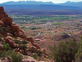
Looking down on Moab, I see an agrarian culture turned host.  Where Mormons came to convert the Utes, and cowboys came to exploit the grass, prospectors to relive the gold rush stories of their grandfathers refitted in uranium, now the neglected arches and needles bring thousands to viewpoint turnouts and loop drives from which they can return to the same gas station and give big tips to waitresses who know how to smooze.

Monday, June 27, 2011

Better than the Golden Sunrise


 We greet each other, the sun and I, across 93 million miles of black void.  Morning is sweeter in the knowledge of what the afternoon will bring, and it’s been bringing it on hotter as July approaches, here on my island in the sun.

 
Again I go to the edge of the world and look down.  Another day, another trail.  This one goes to where the Puebloans would have gone two thousand years ago, followed by the Utes, the Mormons, the cowboys, and today by anyone foolish enough not to carry water.  The old ones would have known about Neck Springs.


After descending  over a gentler place in the cliff, I find it—water.  The plants lead me; they have always known.


Looking up, I see the seamen gaze ahead.  Land Ho, one shouts.  And they too find the Island in the Sky.


Like ships on the sea, Monitor and Merrimac Buttes, named for two iron ships in the Civil War—Merrimac (left), the Confederate ship, Monitor (right) the Union ship.  Entrada Sandstone, rising six hundred feet, same rock as in Arches Park.


Welcome to Upheaval Dome.  So strangely different is this place than anything around here that geologists study it with great interest.  We must, of course, understand every phenomenon, catalog it, and thereby make ourselves feel competent.  It’s what religion does with natural things, artists do on canvas, and what I do in writing this blog.  I’m not criticizing, just lowering our importance.  

Some geologists attribute this two-mile wide mouth to the impact of a comet fragment some sixty million years ago.  Others say that because this whole region is underlain by salt leftover from several ancient seas, and because salt becomes plastic under great pressure, that it welled up in this particular place to form a dome, which eroded to become the blue spectacle you see.

Sunday, June 26, 2011

Brute Force and Compliance


 By the mid 1950’s Moab was bursting at the seams with thousands of prospectors for uranium.  They came to make millions, but few did.  The price of ore fell and the miners left.  A processing plant for uranium ore opened in 1956 and closed in 1984.  What the prospectors left on the landscape is a network of ugly and rugged roads to their would-be mines, to their lost fortunes.  Today, jeeps venture these dare-devil roads.  The perfect wedding for me would be to a jeeper, because he can pick me up along some jeep road where most of the trails end.  Open for proposals.


 “The desert is a good school in which to observe the cleverness . . . of survival under pitiless opposition.  Life could not change the sun or water, so it changed itself”—John Steinbeck 


This country has lured me in, captured me, and after twenty days, has not let go.  From the edge of this island in the sky it is possible to gaze down on the backs of soaring birds, and I shall go there tomorrow for more of it.


Plants and animals with remarkable adaptations for desert survival greet me with apathy.  Some escape the average hell and live in nooks where the desert is less harsh—cottonwoods, single-leaf mahogany.  Some live only when the desert relents its cruelty—the annuals—and resign their species to seed for the harsh times of year.  And some, like the juniper, just stick it out in some crack in rock and simply die back if rain delays its blessing.


Along the great river, everything changes.  Anything can grow.  But just a hundred feet from the river, life in all its starkness resumes.

Saturday, June 25, 2011

Island in the Sky


The northern part of Canyonlands National Park is cut off from the southern part by the deeply gorged of Colorado River.  Land above the two-thousand-foot, vertical-walled chasm, is almost flat and quite fertile.  


I showed the gorge on Wednesday from Dead Horse Point.  Today I walked out on the mesa above the river they call Island in the Sky, like a floating platform for life and meandering. I walked several miles to the edge-of-the-world where another step would take me almost straight down to the muddy river.  


Soil is fairly deep up here at six thousand feet.  It retains enough of the meager rainfall to grow a healthy crop of grass.  I walked through waist-high grass today, but it was not always so.  Cattlemen used to graze their herds here where fences are not needed, the drop-off being sufficient to keep the animals “in.”  Now that it’s a national park the grass grows high, and among the tough clumps are many wildflowers.  I wish I knew all their names.


I walked on the flat mesa enjoying the flowers before finding a string of rock cairns that pointed a way over the edge.  I might have gone all the way down to the river, but saw no point.  Just enough hiking to get tired, not enough to make tomorrow hard.  Just enough to find a few unique places, not so much that they become mundane.

Friday, June 24, 2011

La Sal Mountains


Only seven days remain here in Moab; more than two-thirds of my time passed lickety-split.  A mostly lonesome passage from human interaction to enthrallment with ancient, wonderfully complex rock.


Every day in Arches Park, I would come eventually to a high place where, instead of red sandstone shaped by physics or God into forms that demand attention, I would cast a wistful eye to the La Sal Mountains some thirty miles to the southeast.  At thirteen thousand feet, their peaks stand some eight thousand feet higher than me, rosy in the morning sun, with blue scarves of snow flying in the wind.  See one of those views from Arches above.


 When I arrived on June 7, I bought a trail map and asked how the trails might be faring.  With some three times normal snowfall last winter and melting fast—not so well, I was told.  So I waited until today to go.  I drove high among  these alluring peaks, and then took to a trail.


Driving upward through pygmy forest of juniper and piñon pine.  On up come the scrub oak jungles, the Manzanita, sumac and dogbane.  

Quaking aspen, tall, straight slim trees with bark as white as the birches of International Falls, The foliage responds to the slightest movement of air.


I climb into a springtime of flowers—larkspur with thick stem and deep blue petals; blue flax with pale sky-blue petals veined in violate, state flower of Utah.

Climbing higher, red fir and lodgepole pine forest, subtle fragrance of sun-warmed, oozing resin.  I climb to nine thousand feet and see timberline at about eleven thousand, the peaks two thousand feet above that.